|
The Warby Range State Park |
Extending for 25 kilometres north of the town of Glenrowan is a steep scarped range known locally as the Warbys. The combination of excellent viewing points along the ridge, pleasant picnic spots, an outstanding variety of birdlife and wildflowers, a large range of bush walking tracks and some magnificent waterfalls in the wet season makes a visit to the Warbys worth while.
Lookouts
Powers Lookout ( King Valley )
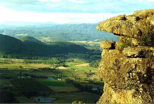 |
The above lookout is Powers Lookout from the King Valley.
This is not part of the Warbys but is a spectacular lookout to which you can drive to within approximately 100 metres.
Maps are available at the Wangaratta Tourist Information Centre.
Grand views of the Victorian Alps, and the Ovens and King Valley.
From this vantage point there is no better place to view the the Ovens and King Valleys and the Victorian Alps.
The walk to the lookout begins at the style at Taminik Gap, on Taminik Gap Road, and the walk follows the Ridge Track. It is a 9 kilometre return walk, of a moderate to easy grade, with one steep section of sealed road leading up to the Telstra towers near the start of the walk.
This is a moderate to easy walk to the Pangarang Lookout, which offers excellent panoramic views to the west taking in Mt Major and the Murray Valley. The walk begins from Ferris Road and is a three kilometre return walk.
Views from the Ryan's lookout are exceptional, especially in winter with snow covered peaks in the distance. Barbeque facilities are available at the lookout. Ryan's Lookout has a car park, and the lookout platform is about 100 metres from the car park. From Wangaratta drive along Wangandry Road and you will see the sign for Ryan's Lookout on your right.
 |
 |
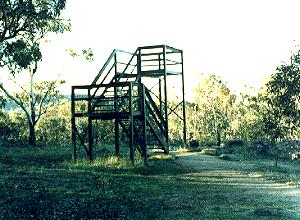
This is the site of the Warby Fire Tower. Driving from Wangaratta along Wangandry Road, pass Ryans Lookout and turn right into Adams Road, left into Tower Road near the Spring Creek Picnic Area, and right into Cox Road. The Fire Tower is 377 metres.
Maps are available at the Wangaratta Tourist Information Centre.
Walking Tracks
This two kilometre self guided loop walk provides a good interpretation of the park's natural values. The walk should take around an hour to complete, with the track being steep and rocky in places. The waterfall with the valley below are well worth the walk.
Driving from Wangaratta along Wangandry Road, pass Ryan's lookout, cross Adams Road and look for a large sign on your left.
This walk starts from Wenhams Camp and is a moderate 4.6 kilometre loop track taking approximately 2 hours to complete. The walk takes in a variety of vegetation communities and guide notes are available at the start of the track, provided by the Friends of the Warbys.
Half way through the walk there is the opportunity to divert from the track to Kwat Kwat Lookout ( one kilometre return ) which offers excellent views of the Ovens Valley and Victorian Alps.
From Wangaratta travel along Wangandry Rd, and turn left at Gerrets Road, ( opposite Ryan's Lookout ). Veer left onto Booth Road, passing Taylors Track on your left and Hoystels Track on your right. Park at the picnic area, toilets provided, and follow the signs.
A series of tracks provide a choice of 2 kilometre to 6 kilometre walks ranging from moderate to hard. The walk starts from the end of Delloro Road and climb up to the plateau to the west.
During spring a variety of wildflowers beautify the area, with the vegetation being relatively undisturbed. At the start there is a 1.5 kilometre return walk to the quarry where granite was obtained to build the Anglican Cathedral in Wangaratta.
Driving from Wangaratta head towards Glenrowan on the Old Hume Highway, pass Stanley Street on your right and Delloro Road is the next Right.
This is a short walk to Salisbury Falls which are only active in the wet season.
Driving from Wangaratta, head towards Glenrowan on the Old Hume Highway, and turn right at Shanley Street. The walk commences at the end of Shanley Street.
This is a moderate to easy walk to the Pangarang Lookout, which offers excellent panoramic views to the west taking in Mt Major and the Murray Valley.
The walk begins from Ferris Road and is a 3 kilometre return walk.
Driving from Wangaratta take the Wangandry Road, past Ryan's lookout, past Adams Road, past Pine Gully Nature Walk, and turn right into Ferris Road. You will see the signs, park at or near the gate to the Pangarang Track.
From this vantage point there is no better place to view the the Ovens and King Valleys and the Victorian Alps.
The walk to the lookout begins at the style at Taminik Gap, on Taminik Gap Road, and the walk follows the Ridge Track. It is a 9 kilometre return walk, of a moderate to easy grade, with one steep section of sealed road leading up to the Telstra towers near the start of the walk.
Driving from Wangaratta, head towards Glenrowan on the Old Hume Highway, pass Shanley Street, and Delloro Road on your right, and turn into Taminik Gap Road on your right.
Drive to the top of the range, and you will see the sign on your left re the Mt Glenrowan Track.
Black Springs is a permanent spring, which makes it the ideal place to viewing wildlife.
Driving from Wangaratta, along Wangandry Road, at Ryan's lookout, turn left into Gerrets Road, past Booth Road on your left, and turn left into Griffith Track. Pass post Patch Track and stop at Nightjar Track on your left.
The walk commences at Nightjars Track, and the Black Springs is at the junction of Nightjar and Post Patch Tracks.
Brien's Gorge and Jubilee Waterfall Walk
A short walk to the Jubilee Falls in winter and spring.
Driving from Wangaratta along the Wangandry Road, turn left into Jubilee Road, and left again into Grandview Road, and follow the track past the Golf Course to the parking area. from here it is only a short walk to the falls. Note the many Blackboys or Grass Trees along the way.
Maps are available at the Wangaratta Tourist Information Centre.
Waterfalls
This is a magnificent waterfall when the creek is running.
It is only about 300 metres from the car park and picnic area. Follow the trail from the car park, but do not cross the creek to commence the Pine Gully Nature Walk.
Walk south along the western side of the creek and you will come upon a magnificent set of granite waterholes, culminating in a spectacular waterfall into the valley many metres below.
See photo in Pine Gully Nature Walk.
A short walk to the Jubilee Falls in winter and spring.
Driving from Wangaratta along the Wangandry Road, turn left into Jubilee Road, and left again into Grandview Road, and follow the track past the Golf Course to the parking area. from here it is only a short walk to the falls. Note the many Blackboys or Grass Trees along the way.
This is a short walk to Salisbury Falls which are only active in the wet season.
Driving from Wangaratta, head towards Glenrowan on the Old Hume Highway, and turn right at Shanley Street. The walk commences at the end of Shanley Street.
Animals, Birds, Wildlife
Most of the animals in the Warbys are nocturnal and not easy to spot during the day. Occasionally one may see dark furred Swamp Wallabies or Eastern Grey Kangaroos darting off into the bush, disturbed by your vehicle or your approaching footsteps.
The exposed granite slabs are ideal sunning sites for snakes and a number of lizards, including the big Lace Monitor.
The open woodland offers plenty of habitat for birdlife including Rosellas, Robins, the Wedge Tailed Eagle, Eastern Spinebill and White throated Treecreeper.
The Warby Range Forest is an important location for the survival of endangered species such as the Squirrel Glider, Feathertail Glider, Barking Owl, Turquoise Parrot and the Carpet Python.
| Wangaratta Bike Paths | Tiger Moth Joy Flights |
| Wangaratta Wineries | Grass Trees |
| Wangaratta Attractions | Bush Walks |
The Up Button takes you to the Home Page