|
Bicycle & Walking Tracks |
The Gateway Island Bicycle and Walking Track
and
Wiradjuri Walkabout, Aboriginal River Walk
Bicycle and Walking Track 4.90 Km
1 Union Bridge via Murray River, Wiradjuri Walkabout
| To Picnic Area | 1.38 Km |
| To River Junction | 2.20 Km |
| To Birdhide | 3.10 Km |
| To Lincoln Causeway | 3.50 Km * |
| Back to Start, round Circuit | 4.90 Km |
* To get to the junction of the Lincoln Causeway track and the Murray River Track takes 3.50 Km along the River and only 1.4 Km along the Causeway.
2 Union Bridge via Lincoln Causeway to Sumpsion Gardens and Wodonga Station 4.20 Km
| To Turnoff to Birdhide | 1.40 Km * |
| To Wodonga Creek | 2.40 Km |
| To Wodonga Freeway Underpass | 2.80 Km |
| Turn Left | |
| To Sumpsion Gardens | 3.20 Km |
| Sumpsion Gardens Lake Circuit | 1.20 Km |
| To Wodonga Station | 4.20 Km |
3 Union Bridge via Lincoln Causeway to House Creek, Swing Bridge, Les Stone Park and Willow Park 6.30 Km
| To Turnoff to Birdhide | 1.40 Km * |
| To Wodonga Creek | 2.40 Km |
| To Wodonga Freeway Underpass | 2.80 Km |
| Turn Right | |
| To Sangster Rd & House Creek | 3.80 Km |
| To Swing Bridge, Wodonga | 4.60 Km |
| To Les Stone Park | 5.10 Km |
| To Willow Park | 6.30 Km |
Bike Path One
Union Bridge via Murray River, Wiradjuri Walkabout
| To Picnic Area | 1.38 Km |
| To River Junction | 2.20 Km |
| To Birdhide | 3.10 Km |
| To Lincoln Causeway | 3.50 Km * |
| Back to Start, round Circuit | 4.90 Km |
The Aboriginal walkabout incorporates only the first 3.10 Km of the Track. Display signs will show you various aboriginal items, such as Bush Food and Medicine Plants, Aboriginal Carvings in Trees, Cooking Sites, Traditional Campsites, Canoe Making and a Birdlife Sanctuary.
This Walking/ Cycle track commences on the Victorian Side of the Union Bridge, on the Eastern side of the Highway. The Union Bridge is where the Hume Highway crosses the Murray River, which is also the New South Wales and Victorian Border.
( Under the Bridge is a connection to the Albury to Lavington Bicycle path, which follows the Bungambrawatha Creek approximately 8 Km to the corner of Urana Road and Pearsall Street, near the Lavington Primary School ).
 |
 |
 |
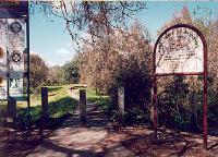
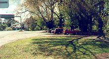
The Start of the Wodonga Bike Trail is at the Union Bridge over the Murray River. The centre photo above you can see the car park on the Eastern side of the Hume Highway, immediately before the Bridge. There are Two Starting Points here!
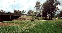
On the left photo above you can see the Start of the Bike Path along the River. By Turning right or following the Highway towards Wodonga is the Start of the more direct path to Wodonga. On the photo on the right you can see how this path follows the Hume Highway and then goes underneath the Highway to join the Bike Path to Wodonga along the Lincoln Causeway.
Note, The Lincoln Causeway was named after Merv Lincoln, a Wodonga athlete who represented Australia at the 1954 Olympic Games. Merv was a sub four minute miler.
|
|
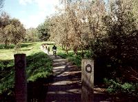
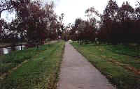
Commence riding along the Murray River towards Wodonga, as per the two photos above.
|
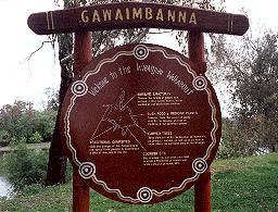
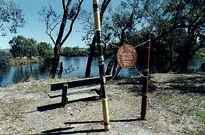
You will come to a large Aboriginal Sign behind the Old Brewery. This will be the first of many signs.
|
|
Above left we can see the picnic area accessable by car, on the western side of the Historic Railway Bridge over the Murray River. There are barbeque facilities and tables here. The photo on the right is about 1 Km further along, and shows two very interesting features.
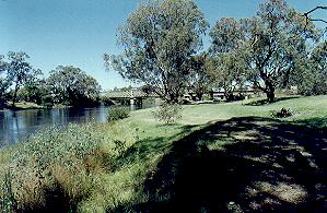
Firstly the aboriginal walk has a display of didgeridoos, and an explanation of their manufacture and use. Secondly in the background you can see the Murray River. It is at this point that the river hits a " T Intersection," and veers right to Albury as the Murray River, and veers left to Wodonga as the Wodonga Creek.
The two rivers join again about 4 Km downstream, and it is this division and rejoining that creates the Gateway Island.
Links to Other Bicycle Paths |
| Murray River Bike Path | Border to Wodonga Stn | Border to Willow Park |
| Lavington to Albury | Albury Hovell Tree Path | Bright Rail Trail |
The Up Button will take you to the Home Page