Reform Hill Walk
Reform Hill is located at the south eastern end of Myrtleford, opposite the Old Butter Factory. The hill provides a picturesque backdrop of native forest, the typical trees include Red Box, Long-leaf Box, Red Stringybark and Broadleaf Peppermint.
 |
Reform Hill takes its name from a rich Gold Bearing Quartz Reef discovered in 1854. Trial crushings yielded a high proportion of gold, ten ounces to the ton. The gold bearing quartz was in places 7 metres wide and ran through the core of the hill.
This reef brought about the development of Myrtleford due to the long term nature of quartz reef gold mining and the area's location on a fertile valley. John Riley was allotted 100 yards of reef which became known as the Reform and from there the mine grew rapidly.
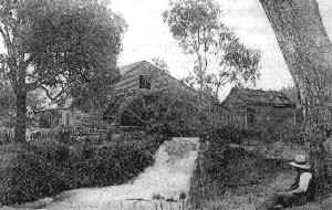 |
To crush the quartz stone, the Reform Battery was erected on the Banks of the Happy Valley Creek opposite the mine tunnel entrance, very near where the Old Butter Factory is today. Above is an historical photo of the battery. The battery was powered by a water wheel about 5 metres in diameter and treated the stone of the district at a cost of 33 shillings per ton. It could crush about 19 tons of quartz per day, 24 hours per day, 6 days a week.
For over 30 years the Reform Mine was a principal employer within Myrtleford, with the miners paid around 2 pounds and 10 shillings a week, ( about $5 ) in the mid 1880's. The mine closed in 1888 due mainly to a large amount of water entering the shafts. It is estimated that the mine produced around 21,500 ounces of gold, which at todays prices, ( 2002 ), would be worth around 13 Million Dollars.
Today Reform Hill is a peaceful recreation area which is also an exception Lookout, providing magnificent views over the Myrtleford Township and and along the Ovens Valley. Reform Hill provides short walks for both the locals and the tourists.
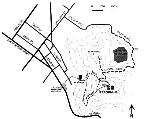
The outstanding feature of the Reform Hill Lookout is that you may drive your car to within 50 metres of the top, or you may walk along two tracks. This factor gives you many options.
 |
Drive to Lookout
As per the map above, to drive to the lookout you head east along Standish Street, turn right into Halls Road, and keep driving, continuing as the road turns to gravel, passes the Reservoir on your right, and you follow the signs to the Lookout. The road is steep and gravel, but any type of car can easily navigate the road to the top.
Walk to the Lookout
The walk to the lookout commences at the J A Jones Memorial Reserve, which is the park on the left hand side of the Highway on your way south out of Myrtleford to Bright. This reserve has picnic facilities, with tables and barbeque facilities.
 |
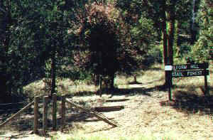 |
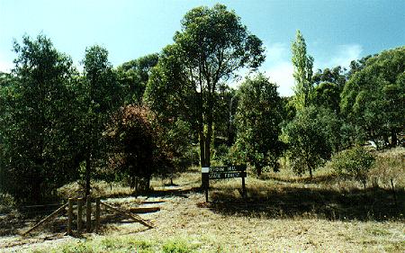
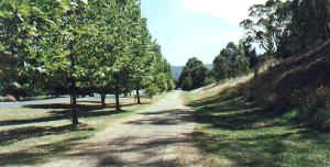
Above left you can see the Rail Trail heading straight into Myrtleford, with the Jones Memorial Reserve on its left, the Highway further left, and the Reform Hill on its right. The entrance to the Reform Hill Walk is on the photo to the right, where a pedestrian only gate has been made out of wooden posts, with the track winding into the forest and passing the carved wooden sign post which says Reform Hill State Forest.
| Museum | Rail Trail |
| Trees and Lakes | Reform Hill Walks |
The Up Button will take you to the Home Page