BEECHWORTH'S FOREST DRIVE |
26 KILOMETRES
This scenic drive, which starts and finishes in Beechworth, takes you through hardwood forests and softwood plantations typical of the North East Victorian foothills. Follow the route in a clockwise direction using the map on this page or one you may obtain from the Tourist Information Centre, and watch for the symbols and arrows along the way.
To commence the drive, travelling south along the main street of Beechworth, Ford St, with the gaol behind you, turn left at the post office into Camp St, and then left again into High St., passing the back of the gaol on your left, and travel approximately 1 Km, then turn right down Elgin Rd. After approximately half a Km, turn left into Red Hill Road and you are on your way.
The trip takes a leisurely 11/2 hours, but this may be longer if you stop to see all the fascinating sites, or for a picnic lunch at the many ideal places.The roads are narrow but suitable for all weather traffic. Log trucks also use the forest roads.
The tour passes through the Stanley plantation, the township of Stanley, the Gold mining area around the Wallaby Mine, and the eucalypt forest of the Dingle Range. At Stanley, you may choose to do a one hour side trip of about 19Km to the top of Mt Stanley. The views are magnificent.
YELLOW is the Beechworth Historic Park
BLUE are the Lakes
GREEN is the State Forests
PURPLE is the Victorian Plantations Corporation
To commence the drive, travelling south along the main street of Beechworth, Ford St, with the gaol behind you, turn left at the post office into Camp St, and then left again into High St., passing the back of the gaol on your left, and travel approximately 1 Km, then turn right down Elgin Rd. After approximately half a Km, turn left into Red Hill Road and you are on your way.
1 The Mansions
When you first come to the pine plantations, a sign directs you to to take a left turn off the main forest drive. Follow the signs to the Mansion Picnic area. The picnic area and toilets are located at the site of one of the earliest homesteads in the Beechworth District. An information board describes the history of the house. Only the foundations and well remain today, along with the old cypress trees. Retrace your route to the main forest drive.
2 Mansion Plantation
This is the second rotation of Pinus Radiata planted in 1988/89/90. The original plantation was planted during the 1930's Depression years by sustenance workers. The trees were harvested and sawn into boards. Offcuts and smaller trees were made into paper.
Pines in the Stanley area were originally planted on degraded mining land by Forest Commission employees and sustenance workers. Sustenance camps near Stanley were established by unemployed men from Melbourne during the Depression in the 1930's. The plantations were worked by Italian Interns during World War 2, and following the war, by immigrants who came to Australia through naturalisation programs during the 1950's and 60's.
The area managed by the Victorian Plantations Corporation, locally based at Myrtleford, is now in its second and third rotation. The pines are thinned at approximately 15 and 20 years to provide pulp for newsprint, tissue and particle board, finally being cleare felled at 28 to 30 years for veneer and sawlogs. The area is then immediately replanted being the next crop rotation.
3 Beechworth Historic Park
This part of the park is typical of the dryer foothill forests of the Victorian North East. The main tree species include Red Stringybark, ( Eucalyptus macrorhyncha ), Narrow Leaf Peppermint, ( E. radiata ), Brittlegum, ( E. mannifera ), and Apple Box (E. bridgeesiana ).
If you take a walk along one of the side tracks you may observe some of the local birds and other wildlife.
4 Lake Kerferd
This picturesque Lake supplies Beechworth's town water, and as such camping, swimming and boating are not permitted at the lake, although fishing is still a popular activity throughout the year.
Named after George Kerferd, who advocated the Dam's construction, the dam was officially opened in 1874, giving the town a permanent water supply. G Kerferd was a prominent Beechworth citizen, who was elected Mayor of Beechworth 3 times, subsequently going on to become Premier of Victoria.
5 Wallaby Gold Mine
Located approximately 3 minutes drive from the main forest drive route, the mine offers an insite into the mining activities that took place in the area during the 19th century. the mine is listed on the Victorian Heritage Register to ensure that it is protected for future generations.
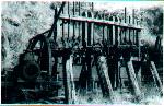 Wallaby Mine Gold
Battery
Wallaby Mine Gold
Battery
6 Hurdle Flat
The area surrounding the present picnic area was a thriving Hamlet during the Gold Rush of the 1870's. Little trace remains of the houses, hotels, public hall, school and racecourse which stood here in its heyday.
7 Fletchers Dam
This small picturesque lake set amongst pines was an old gold mine, and is now a popular recreational area. Toilets and picnic facilities are provided, and there is a walking track around the lake. The lake has been known to provide many a good fish.
8 Californian Redwoods
After the airstrip you may wish to turn left and follow the Number One Road east for 900 metres, a little beyond Nine Mile Creek, to a magnificent stand of Californian Redwoods planted in 1936.
To keep them company,, there is also another tree from the west coast of Canada and USA nearby. It looks something like a pine tree, but it is actually a Dougla Fir, also planted in 1936.
Return back to the forest drive.
9 Demonstration Stands
This series of Demonstration Stands shows the difference between several conifer species. From here you will pass through the site of the old Stanley Nursery, where pine seedlings were raised for planting until the early 1960's.
10 Ponderosa Pine
This stand of trees was planted in 1931. Trees can have more than one common name, particularly in different localities. These may be called either Ponderosa Pine or Western Yellow Pine. This is why botanists use Latin sounding scientific names for plants, to ensure that the same name referrs to the same species all around the world. You are looking at Pinus Ponderosa. The Myrtleford Tourist Information Centre is situated in the Ponderosa Cabin, built from these same pines.
11 Apple Orchards
In this area you will see many apple orchards.After the Gold Rush, many of those remaining in the Stanley district began growing apples for income. The climate and the soils proved to be suitable and over the years the industry has flourished. More recently the district's fruit industry has seen an increase in crop diversification with the growing of cherries, nectarines and other stone fruits and nuts.
12 Stanley
Originally known as Snake Gully, Stanley was a bustling Gold mining town in the 1850's and 60's. In 1857 the township was surveyed and officially named Stanley. By this stage there were over 5000 people residing in the area. The town had a number of hotels, a bakery, a general store, a brewery, a bootmaker, a carpenter, a butcher and a sawmill.
Today Stanley has a general store and the Indigo Inn. While the building has been replaced, the site and licence remain the original. Opening as the Star Hotel, in the 1850's, it was part of J A Wallace's chain of hotels accross North East Victoria, all named The Star.
13 Mt Stanley
If you wish to visit Mt Stanley, turn left at the T intersection near the General Store, and follow the bitumen to the end, then the main gravel road as it continues to climb. You should reach the summit in 10Kms and about 20 minutes.
The scenery from here is magnificent with views of the Australian Alps from Mt Kosciusko to Mt Buller.The steel lookout tower on the summit was built in 1932 for fire detection purposes, and was one of the first built in Victoria. There are picnic facilities here.
Return to the Stanley Township.
To continue on the Forest Drive, turn Right at the T intersection past the Star Hotel, and turn right off the bitumen onto Six Mile Road, just before the speed restriction sign.
14 Sluicing ( Gold Mining )
You will notice along the right hand side of the road, the lower level of ground. These are examples of sluised out banks. Sluicing is one form of Gold Mining, which was adopted to mine large areas for alluvial gold deposits.
To sluice, the miners used water under pressure and aimed a funnel, similar to the current day fire hose, which washed the gravel ground away into races where the gold, being heavier, was teapped in ridges set on the bottom, while the remaining gravel and soil, sludge, was washed away.
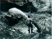 Sluicing at the
Stanley Area.
Sluicing at the
Stanley Area.
15 Stanley State Forest
The unusual tree next to the marker is a Brittlegum and a Narrow leaf Peppermint which have grown together. The forest along this section of the drive can be seen in the surrounding moist gullies and drier ridges.
The gullies generally contain stands of Blue Gum, Narrow Leaf Peppermint, and Candlebark. Understory species include Dogwood, Silver Wattleand Bracken Fern.
As the road climbs onto the drier ridgetops, the vegetation in the forset changes. Main tree species include Red Stringybark, Broad Leaf Peppermint and Blackwood. Understory species in these drier areas include a variety of of native orchids and other wildflowers, usually best seen during spring.
16 Dingle Range
The Six Mile Road passes through the hardwood forests of the Dingle Range. The species are as above.
17 Clarks Corner
At this fork intersection, veer right to reach Clark's Corner picnic area. The hose that stood here until early this century was once occupied during the Gold Mining era by William and Eliza Clark and family. The Clarks ran a small market garden supplying miners with fresh products.
During the late 1940's and 50's, a small group of migrants were assigned to work for the Forset Commission to assist in road construction. They also lived in this section of forest in a portable hut that was later moved to the Elbow Camp, near Stanley.
18 Murmungee Lookout
From here you can look over the cropping and grazing lands of the Murmungee basin. Further south is the Ovens Valley, and beyond, the horizon is silhouetted with the magnificence of the Victorian Alps from Mt Buffalo to Mt Buller. The facilities at this site make it a great place to stop for a picnic lunch with a fantastic view.
19 Buckland Gap
Once the site of The Royal Oak Hotel. In the days of the horse drawn carriage, this Buckland Gap was renowned for the thrill of the ride over it. The Buckland carriage was fitted with a third brake, which could be operated by nervous passengers when negotiating the steep descent to the south of the gap.
Turn right and return to Beechworth, about 6Km.
Beechworth's Ride and Drive Trails |
For more Information on Beechworth Tourist Attractions, please call the Information Centre on 0357 283 233 |
The Up Button takes you to the Home Page